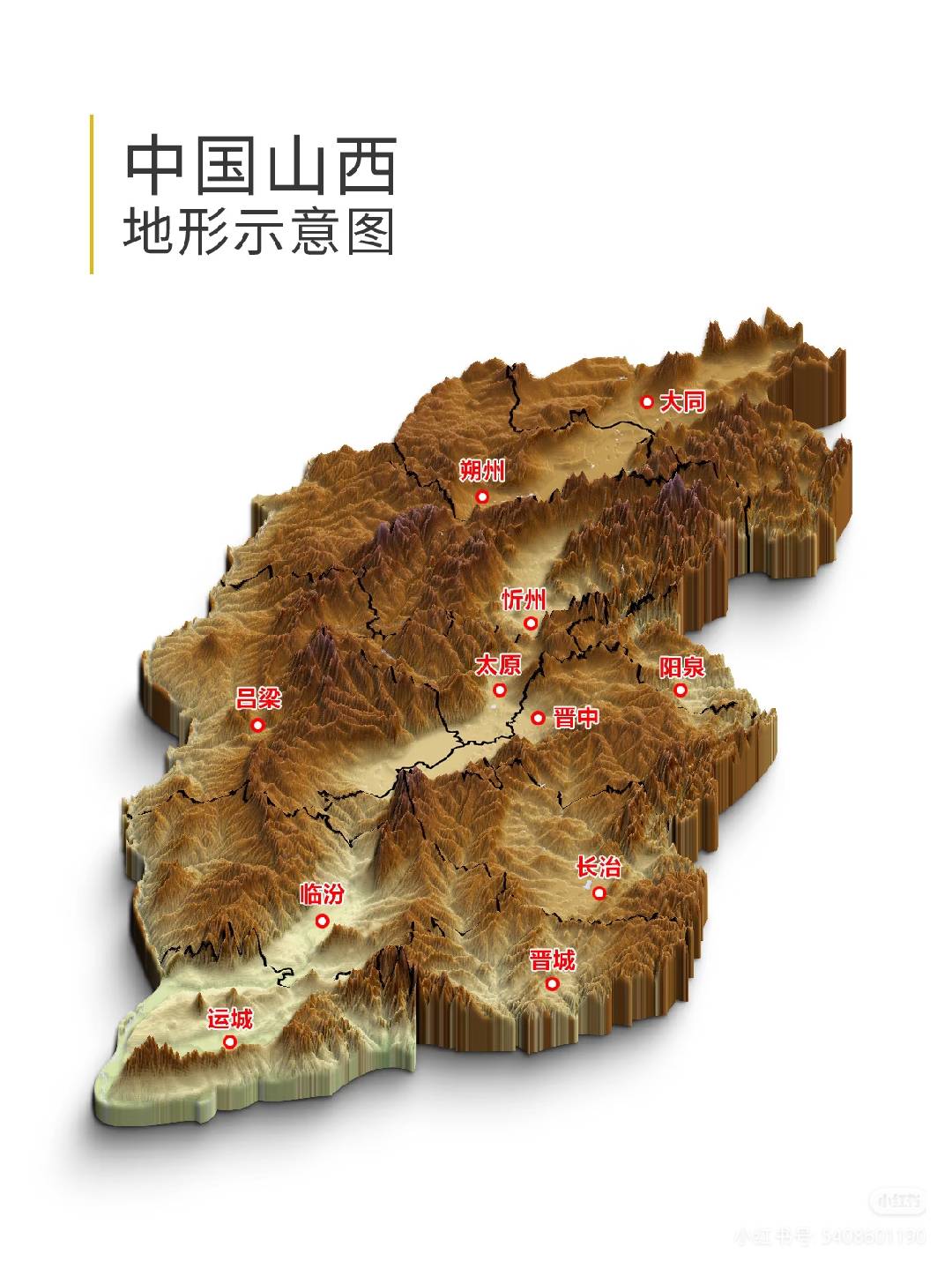
山西3D地形图 —— "两山夹一川"的格局清晰可见3D terrain map of Shanxi — the "two mountains flanking one river" pattern is clearly visible산시 3D 지형도 —— "두 산이 하나의 강을 품은" 구조가 선명하다
🗺️ 地理格局总览Geographic Overview지리 구조 총람
东边是太行山,像一道巨墙把山西和河北、河南隔开;西边是吕梁山,和黄河一起构成山西的西部屏障;中间是汾河谷地,从北到南串起大同、忻定、太原、临汾、运城五大盆地——这条谷地就是山西几千年来人口最密集、经济最发达的核心地带。
整个山西地势东北高、西南低,平均海拔1000米左右。黄河从北面的偏关入境,沿西界南下,在风陵渡拐弯东去——山西三面环河(黄河),一面靠山(太行),这就是"表里山河"的由来。 Shanxi's geography in one phrase: two mountains flanking one river valley.
To the east, the Taihang Mountains form a giant wall separating Shanxi from Hebei and Henan. To the west, the Lüliang Mountains and the Yellow River create a western barrier. In between, the Fen River Valley threads through five major basins from north to south — Datong, Xinding, Taiyuan, Linfen, and Yuncheng — forming Shanxi's most populated and economically vital corridor for millennia.
The terrain slopes from northeast to southwest, averaging about 1,000m elevation. The Yellow River enters from the north at Pianguan, flows south along the western border, and turns east at Fenglingdu — Shanxi is embraced by river on three sides and mountain on one. This is why it's called "mountains within, rivers without." 산시 지형을 한마디로: 두 산이 하나의 강 계곡을 감싸고 있다.
동쪽의 태항산맥은 거대한 장벽처럼 산시를 허베이·허난과 분리한다. 서쪽의 여량산맥과 황하가 서부 방벽을 형성한다. 그 사이를 분하 계곡이 남북으로 관통하며 다퉁·흔정·타이위안·린펀·윈청 다섯 대분지를 연결한다——이 계곡이 수천 년간 산시의 인구·경제 중심이었다.
지세는 동북이 높고 서남이 낮으며, 평균 해발 약 1,000m이다. 황하가 북쪽 편관에서 들어와 서쪽 경계를 따라 남하한 뒤 풍릉도에서 동쪽으로 꺾인다——산시는 삼면이 강(황하), 일면이 산(태항)으로 둘러싸여 있다. 이것이 "표리산하"의 유래이다.
⛰️ 主要山脉Major Mountain Ranges주요 산맥
太行山Taihang Mountains태항산맥
绵延400多公里,是山西与河北、河南的天然分界线。"太行八陉"(八条穿越太行山的通道)是古代出入山西的生命线。壁立千仞,自古就是兵家必争之地。太行大峡谷、王莽岭、锡崖沟挂壁公路,都是太行山的杰作。Stretching over 400 km, the Taihang range forms the natural boundary between Shanxi, Hebei, and Henan. The "Eight Passes of Taihang" were ancient lifelines for entering and leaving Shanxi. Sheer cliffs rising thousands of meters — a contested military chokepoint since antiquity. The Taihang Grand Canyon, Wangmang Ridge, and the cliff-hanging road of Xiya Gully are all masterworks of this range.400여 km에 걸쳐 산시와 허베이·허난의 천연 경계를 이룬다. "태항팔형"(태항산을 관통하는 8개 통로)은 고대 산시 출입의 생명선이었다. 천 길 절벽이 솟아 예로부터 병가필쟁지였다. 태항대협곡, 왕망령, 석애구 절벽도로 모두 태항산의 걸작이다.
吕梁山Lüliang Mountains여량산맥
山西西部的南北纵贯山脉,与黄河一起构成山西的西部屏障。这里是黄土高原最典型的地貌——千沟万壑、梁峁起伏。"人说山西好风光,左手一指太行山,右手一指是吕梁。"吕梁也是革命老区,贺龙、关向应在这里创建了晋绥根据地。Running north-south through western Shanxi, the Lüliang range and the Yellow River together form the western barrier. This is the most typical Loess Plateau landscape — thousands of gullies and undulating ridges. "They say Shanxi has fine scenery — point left, there's Taihang; point right, there's Lüliang." Lüliang is also a revolutionary base area where He Long established the Jin-Sui base.산시 서부를 남북으로 종관하는 산맥으로, 황하와 함께 서부 방벽을 형성한다. 황토고원의 가장 전형적인 지형——수천 개의 골짜기와 기복하는 능선. "산시 풍경이 좋다 하네, 왼손 가리키면 태항산, 오른손 가리키면 여량산." 여량은 혁명 근거지이기도 하여, 허룽이 진수 근거지를 이곳에 창건했다.
五台山Mount Wutai오대산
五座台顶(东西南北中)围成一圈,最高的北台叶斗峰海拔3058米,是华北最高峰——没错,华北最高的山在山西。佛教四大名山之首,文殊菩萨道场,同时也是世界文化遗产。 → 五台山专题Five flat peaks (East, West, South, North, Central) form a ring. The highest, Yedou Peak on the north terrace, reaches 3,058m — the highest point in North China. Yes, North China's tallest mountain is in Shanxi. The foremost of China's four sacred Buddhist mountains, seat of Manjusri Bodhisattva, and a UNESCO World Heritage Site. → Wutai Shan Feature다섯 개의 평평한 봉우리(동서남북중)가 고리를 이루며, 가장 높은 북대 엽두봉은 해발 3,058m——화북 최고봉이다. 그렇다, 화북에서 가장 높은 산이 산시에 있다. 중국 4대 불교 명산의 으뜸이자 문수보살의 도량이며 유네스코 세계문화유산이다. → 오대산 특집
恒山(北岳)Mount Heng (Northern Sacred Peak)항산 (북악)
五岳之中的北岳,主峰天峰岭海拔2016米。"恒山如行"——气势绵延不绝。最出名的其实是悬在半山腰的悬空寺,三教合一,凌空而建,李白当年看了题了"壮观"二字。The Northern Sacred Peak of China's Five Sacred Mountains, with its main peak at 2,016m. "Hengshan is like a march" — its momentum stretches endlessly. The most famous sight is actually the Hanging Temple (Xuankong Si), built mid-cliff, combining three religions. Li Bai visited and wrote just two characters: "Magnificent."중국 오악 중 북악으로, 주봉 천봉령 해발 2,016m. "항산은 행군하는 듯하다"——기세가 끊임없이 이어진다. 가장 유명한 것은 절벽 중턱에 매달린 현공사로, 삼교합일의 건축이며, 이백이 보고 "장관(壯觀)" 두 글자를 남겼다.
中条山Zhongtiao Mountains중조산
横亘在运城盆地南侧,像一道天然城墙挡在黄河北岸。舜帝曾在这里的历山耕田,传说中的"舜耕历山"就在中条山。抗战时期的"中条山战役"是正面战场最惨烈的战役之一。Stretching across the south of the Yuncheng Basin like a natural wall along the Yellow River's north bank. Emperor Shun allegedly farmed at Lishan here. The Battle of Zhongtiao Mountain during WWII was one of the bloodiest on the front lines.윈청 분지 남쪽에 걸쳐 있으며, 황하 북안을 따라 천연 성벽처럼 뻗어 있다. 순임금이 이곳 역산에서 밭을 갈았다는 전설이 전해진다. 항전 시기 "중조산 전투"는 정면 전장에서 가장 참혹했던 전투 중 하나였다.
芦芽山Mount Luya노아산
山西最美的自然保护区之一。褐马鸡(山西省鸟)的故乡,万年冰洞就藏在这座山里——三伏天洞里温度零下,冰柱晶莹剔透。山上还有天池、悬崖栈道和国内罕见的高山草甸。One of Shanxi's most beautiful nature reserves. Home of the Brown Eared Pheasant (Shanxi's provincial bird), and hiding the Ten-Thousand-Year Ice Cave — subzero even in midsummer, with crystal-clear ice pillars. Also features alpine lakes, cliff walkways, and rare highland meadows.산시에서 가장 아름다운 자연보호구역 중 하나. 갈색귀꿩(산시의 성조)의 고향이며, 만년빙동이 이 산속에 숨어 있다——한여름에도 동굴 안은 영하로, 얼음기둥이 수정처럼 투명하다. 천지, 절벽 잔도, 국내에서 드문 고산 초원도 있다.
🏞️ 五大盆地Five Major Basins다섯 대분지
大同盆地Datong Basin다퉁 분지
山西最北的盆地,桑干河流过。北魏都城平城就建在这里。大同、朔州两市坐落其中。自古是农牧交界、民族融合的前沿,也是抵御北方游牧民族的第一道防线。Shanxi's northernmost basin, traversed by the Sanggan River. The Northern Wei capital Pingcheng was built here. Home to Datong and Shuozhou. Historically the frontier of farming and herding cultures, and the first line of defense against northern nomads.산시 최북단의 분지로 상간하가 흐른다. 북위 도성 평성이 이곳에 세워졌다. 다퉁·삭주 두 도시가 있다. 예로부터 농목 교차·민족 융합의 전선이자 북방 유목민족에 대한 첫 번째 방어선이었다.
忻定盆地Xinding Basin흔정 분지
忻州、定襄、原平一带。滹沱河在这里发源。是大同盆地通往太原盆地的必经之地——雁门关就卡在两个盆地之间。阎锡山、徐向前都是从这个盆地走出来的。Covering Xinzhou, Dingxiang, and Yuanping. The Hutuo River originates here. It's the mandatory passage from Datong Basin to Taiyuan Basin — Yanmen Pass sits right between the two. Both Yan Xishan and Xu Xiangqian came from this basin.흔주·정양·원평 일대. 호타하가 여기서 발원한다. 다퉁 분지에서 타이위안 분지로 가는 필경지로——안문관이 두 분지 사이에 딱 자리잡고 있다. 염석산과 서향전 모두 이 분지에서 나왔다.
太原盆地Taiyuan Basin타이위안 분지
山西的心脏。汾河从这里穿城而过,太原、晋中都在这个盆地里。从春秋赵国的晋阳城,到唐代的"北都",到今天的省会——三千年来一直是山西的政治经济中心。晋祠、平遥古城都在盆地边缘。The heart of Shanxi. The Fen River flows through the city here; Taiyuan and Jinzhong both sit in this basin. From the ancient Jinyang of the Zhao state, to the Tang "Northern Capital," to today's provincial capital — it's been Shanxi's political and economic center for three millennia. Jinci Temple and Pingyao Ancient City lie at the basin's edge.산시의 심장. 분하가 도시를 관통하며 타이위안·진중 모두 이 분지에 있다. 춘추 조국의 진양성에서 당대의 "북도", 오늘의 성도까지——3천 년간 산시의 정치·경제 중심이었다. 진사·평요고성이 분지 가장자리에 자리한다.
临汾盆地Linfen Basin린펀 분지
古称"平阳",传说中尧帝建都之地。陶寺遗址(可能是最早的"中国")就在这个盆地里。汾河在这里已经变得开阔平缓,两岸是山西最肥沃的农田之一。洪洞大槐树、壶口瀑布都在临汾盆地的辐射范围内。Ancient "Pingyang," legendary capital of Emperor Yao. The Taosi ruins (possibly the earliest "China") are in this basin. The Fen River grows wide and gentle here, flanked by some of Shanxi's most fertile farmland. The Great Pagoda Tree of Hongtong and Hukou Waterfall are both within Linfen Basin's reach.고칭 "평양", 전설 속 요제가 도읍한 곳. 도사 유적지(아마도 최초의 "중국")가 이 분지에 있다. 분하가 이곳에서 넓고 완만해지며, 양안은 산시에서 가장 비옥한 농지 중 하나다. 홍동 대괴수·호구폭포 모두 린펀 분지 범위 안에 있다.
运城盆地Yuncheng Basin윈청 분지
山西最南、最低、最热、最富庶的盆地。中条山护其南,黄河绕其西。舜都蒲坂、禹都安邑、关公故里解州都在这里。最神奇的是运城盐湖——中国最古老的产盐地,有人说"中国"二字最早就指这一带。纬度和西安、洛阳相当,冬天能吃到柿子。Shanxi's southernmost, lowest, hottest, and most fertile basin. Zhongtiao Mountain guards its south; the Yellow River winds around its west. Shun's capital Puban, Yu's capital Anyi, and Guan Yu's hometown Jiezhou are all here. The most magical feature: Yuncheng Salt Lake — China's oldest salt-producing site. Some say the word "China" originally referred to this area. At the same latitude as Xi'an and Luoyang, you can eat persimmons in winter.산시의 최남단·최저·최열·최부유 분지. 중조산이 남쪽을 감싸고 황하가 서쪽을 돌아흐른다. 순의 도읍 포판, 우의 도읍 안읍, 관우의 고향 해주가 모두 여기에 있다. 가장 신기한 것은 윈청 염호——중국에서 가장 오래된 소금 생산지로, "중국"이라는 말이 원래 이 일대를 가리켰다는 설도 있다. 시안·뤄양과 위도가 같아 겨울에도 감을 먹을 수 있다.
🌊 主要河流Major Rivers주요 하천
黄河(山西段)Yellow River (Shanxi Section)황하 (산시 구간)
黄河在山西境内流经约965公里,从偏关入境,沿吕梁山西侧南下,在风陵渡拐弯东去。沿途有老牛湾(黄河与长城握手的地方)、壶口瀑布("黄河之水天上来"的现实版)、乾坤湾等奇观。黄河是山西的西界和南界,三面环抱如同护城河。The Yellow River flows about 965 km through Shanxi, entering at Pianguan, running south along the Lüliang Mountains, and turning east at Fenglingdu. Along the way: Laoniu Wan (where the Yellow River and Great Wall shake hands), Hukou Waterfall (the real-life "water of the Yellow River falls from heaven"), and Qiankun Bend. The river forms Shanxi's western and southern borders, embracing it like a moat.황하는 산시 경내를 약 965km 흐르며, 편관에서 들어와 여량산 서쪽을 따라 남하한 뒤 풍릉도에서 동쪽으로 꺾인다. 도중에 노우만(황하와 만리장성이 악수하는 곳), 호구폭포("황하의 물이 하늘에서 온다"의 현실판), 건곤만 등 절경이 있다. 황하가 산시의 서쪽·남쪽 경계를 이루며 해자처럼 감싸고 있다.
汾河Fen River분하
山西最长的河流(716公里),发源于忻州宁武管涔山,贯穿太原、临汾等盆地,在万荣汇入黄河。汾河流域面积占山西总面积的四分之一,养育了山西近一半人口。"汾河流水哗啦啦"——这条河就是山西的命脉。汾酒、汾阳、汾西、临汾…多少地名因它而生。Shanxi's longest river (716 km), originating in the Guancen Mountains of Ningwu, Xinzhou, flowing through the Taiyuan and Linfen basins before joining the Yellow River at Wanrong. The Fen River basin covers a quarter of Shanxi's area and nourishes nearly half its population. Fenjiu (Fen liquor), Fenyang, Fenxi, Linfen — countless place names were born from this river.산시에서 가장 긴 강(716km)으로, 흔주 녕무 관잠산에서 발원하여 타이위안·린펀 등 분지를 관통한 뒤 만영에서 황하에 합류한다. 분하 유역 면적이 산시 전체의 4분의 1을 차지하며 산시 인구의 거의 절반을 부양한다. 분주(汾酒)·분양·분서·임분…수많은 지명이 이 강에서 태어났다.
沁河Qin River심하
发源于沁源,流经长治、晋城,穿过太行山入河南汇入黄河。沁河流域是山西古堡最密集的地方——皇城相府、湘峪古堡、柳氏民居等明清古建群都沿沁河分布。Originating in Qinyuan, flowing through Changzhi and Jincheng, crossing the Taihang into Henan and the Yellow River. The Qin River valley has Shanxi's densest concentration of ancient castles — Huangcheng Xiangfu, Xiangyu Castle, and the Liu Family Residence all line its banks.심원에서 발원하여 창즈·진청을 지나 태항산을 넘어 허난으로 들어가 황하에 합류한다. 심하 유역은 산시에서 고성이 가장 밀집한 곳으로——황성상부·상유고보·유씨민거 등 명청 고건축군이 심하를 따라 분포한다.
桑干河Sanggan River상간하
流过大同盆地,是永定河的上游。丁玲写过《太阳照在桑干河上》。这条河见证了北魏平城时代的辉煌,也见证了无数次北方民族的南下。Flowing through the Datong Basin, it's the upper reach of the Yongding River (which flows through Beijing). Ding Ling wrote "The Sun Shines Over the Sanggan River." This river witnessed both the glory of the Northern Wei Pingcheng era and countless southward invasions of northern peoples.다퉁 분지를 관통하며, 영정하(베이징을 흐르는 강)의 상류이다. 딩링이 《태양은 상간하 위에 비친다》를 썼다. 이 강은 북위 평성 시대의 영화도, 북방 민족의 수없는 남하도 지켜보았다.
滹沱河Hutuo River호타하
发源于忻州繁峙,流经五台山脚下,穿过太行山入河北。忻定盆地的主要河流,也是古代从山西东出太行进入华北平原的重要通道。Originating in Fanshi, Xinzhou, flowing past the foot of Mount Wutai and through the Taihang into Hebei. The main river of the Xinding Basin and an important ancient corridor from Shanxi through the Taihang to the North China Plain.흔주 번지에서 발원하여 오대산 아래를 지나 태항산을 뚫고 허베이로 들어간다. 흔정 분지의 주요 하천이자, 고대 산시에서 태항을 넘어 화북평원으로 나가는 중요한 통로였다.
🏰 雄关险隘Strategic Passes웅관험애
雁门关Yanmen Pass안문관
"天下九塞,雁门为首。"大同盆地与忻定盆地之间的咽喉要道。从李牧到杨业,从汉匈战争到宋辽对峙,雁门关的城墙上浸透了两千年的鲜血。"雁门关外野人家"——关内是中原,关外是草原,一关之隔,两个世界。"Of the nine fortresses under heaven, Yanmen comes first." The throat between Datong and Xinding basins. From Li Mu to Yang Ye, from Han-Xiongnu wars to Song-Liao confrontation, Yanmen's walls are soaked with two thousand years of blood. Inside the pass: the Central Plains. Outside: the steppe. One gate, two worlds."천하구새에 안문이 으뜸이다." 다퉁 분지와 흔정 분지 사이의 인후 요도. 이목에서 양업까지, 한흉노 전쟁에서 송요 대치까지, 안문관의 성벽에는 2천 년의 피가 스며있다. 관 안은 중원, 관 밖은 초원——하나의 관문, 두 개의 세계.
娘子关Niangzi Pass낭자관
太行山上的东大门,山西通往河北的重要关口。传说唐朝平阳公主曾率娘子军在此驻守,因此得名"娘子关"。关前有瀑布飞泻,关内有泉水潺潺——是少有的"既能打仗又好看"的关隘。The eastern gate on the Taihang Mountains, a key pass from Shanxi to Hebei. Legend says Princess Pingyang of Tang once stationed her women's army here — hence "Niangzi (Lady's) Pass." Waterfalls cascade before the pass, springs murmur within — one of the rare passes that's both strategic and scenic.태항산 위의 동쪽 대문으로, 산시에서 허베이로 가는 주요 관문. 전설에 따르면 당나라 평양공주가 여군을 이끌고 이곳을 지켰다 하여 "낭자관"이라 불린다. 관문 앞에는 폭포가 쏟아지고 안에는 샘물이 졸졸 흐른다——전략적이면서도 아름다운 드문 관애이다.
风陵渡Fenglingdu풍릉도
黄河在这里拐了一个近90度的大弯,从南北走向变为东西走向。这是山西、陕西、河南三省交界处,自古是兵家必争的黄河渡口。金庸小说里郭襄在风陵渡口初遇杨过——"风陵渡口初相遇,一见杨过误终身",让这个地名浪漫了起来。The Yellow River makes a near-90-degree turn here, shifting from north-south to east-west. This junction of Shanxi, Shaanxi, and Henan has been a contested river crossing since antiquity. In Jin Yong's novels, Guo Xiang first meets Yang Guo at Fenglingdu — "First meeting at Fenglingdu, one glimpse of Yang Guo ruins a lifetime" — giving this place an unexpected romantic aura.황하가 이곳에서 거의 90도로 크게 꺾이며, 남북 방향에서 동서 방향으로 바뀐다. 산시·산시(섬서)·허난 세 성의 교차점으로 예로부터 병가필쟁의 황하 나루터였다. 김용 소설에서 곽양이 풍릉도에서 양과를 처음 만났다——"풍릉도에서 처음 만나, 양과를 한번 보고 평생을 그르쳤다"——이 지명에 뜻밖의 낭만을 더해주었다.
偏头关·宁武关·雁门关(外三关)The Three Outer Passes외삼관 (편두관·녕무관·안문관)
明代长城防御体系中的"外三关",从西到东分别是偏头关(偏关)、宁武关、雁门关,一字排开扼守山西北部。如果大同盆地失守,这三座关隘就是保卫太原盆地的最后屏障。宁武关还有一个传说中的"万年冰洞"——见芦芽山。The "Three Outer Passes" of the Ming Great Wall defense system, from west to east: Piantou Pass (Pianguan), Ningwu Pass, and Yanmen Pass, lined up to guard northern Shanxi. If the Datong Basin fell, these three passes were the last shield protecting the Taiyuan Basin.명대 장성 방어 체계의 "외삼관"으로, 서쪽부터 편두관(편관)·녕무관·안문관이 일렬로 산시 북부를 방어한다. 다퉁 분지가 함락되면 이 세 관문이 타이위안 분지를 지키는 마지막 방벽이 된다.
💎 地质奇观Geological Wonders지질 경관
大同火山群Datong Volcanic Cluster다퉁 화산군
30多座火山锥,距今约2万年——是中国东部最年轻的火山群之一。虽然是"死火山"(大概率),但这些锥形山丘在大同盆地平坦的地面上格外醒目。黑山、狼窝山、金山等保存完好,像是大地上的一排"小馒头"。Over 30 volcanic cones, about 20,000 years old — one of the youngest volcanic clusters in eastern China. Though "extinct" (probably), these conical hills stand out strikingly on the flat Datong Basin floor. Heishan, Langwo Mountain, and Jinshan are well-preserved, like a row of little "steamed buns" on the earth.30여 개의 화산추가 있으며 약 2만 년 전 형성——중국 동부에서 가장 젊은 화산군 중 하나다. "사화산"(아마도)이지만, 평탄한 다퉁 분지 위에 원뿔형 언덕들이 유난히 눈에 띈다. 흑산·랑와산·금산 등이 잘 보존되어 대지 위의 "작은 만두"처럼 늘어서 있다.
万年冰洞Ten-Thousand-Year Ice Cave만년빙동
芦芽山深处,海拔2300米的山上藏着一个巨大的冰洞——三伏天外面30多度,洞里零下十几度,冰柱、冰帘、冰瀑终年不化。最神奇的是,这里并不在高寒地带,冰洞的成因至今没有完全解释清楚。Deep in the Luya Mountains, at 2,300m elevation, hides a massive ice cave — outside it's 30°C+ in midsummer, inside it's -10°C, with ice pillars, curtains, and frozen waterfalls that never melt. The strangest part: this isn't in an arctic zone, and the cave's formation still isn't fully explained.노아산 깊은 곳, 해발 2,300m 산속에 거대한 빙동이 숨어 있다——한여름 밖은 30도가 넘는데 안은 영하 십여 도, 얼음기둥·얼음장막·얼음폭포가 연중 녹지 않는다. 가장 신기한 것은 이곳이 고한지대가 아닌데, 빙동의 형성 원인이 아직 완전히 밝혀지지 않았다는 점이다.
壶口瀑布Hukou Waterfall호구폭포
黄河上最大的瀑布,也是中国第二大瀑布。300米宽的黄河水突然被挤进50米宽的壶口,万马奔腾般跌落——"黄河之水天上来"写的虽然不是壶口,但壶口最配这句诗。50元人民币背面印的就是它。The largest waterfall on the Yellow River and China's second largest. The 300m-wide Yellow River suddenly squeezes into a 50m-wide mouth and thunders down like ten thousand galloping horses. The back of the 50 yuan banknote features this very waterfall.황하 최대의 폭포이자 중국 제2의 폭포. 300m 너비의 황하가 갑자기 50m 너비의 호구로 밀려 들어가며 만마분등하듯 떨어진다. 50위안 지폐 뒷면에 인쇄된 것이 바로 이 폭포이다.
运城盐湖Yuncheng Salt Lake윈청 염호
中国最古老的盐湖,面积132平方公里——比杭州西湖大20多倍。4600年前就开始产盐,有人考证"运城"的"运"就是"运盐"之意。这片盐湖可能是华夏先民争夺的最早资源,黄帝与蚩尤之战的"解之战"传说就发生在这里。近年来盐湖变成了"中国死海"旅游景点,夏天湖水还会变成粉红色。China's oldest salt lake, covering 132 km² — over 20 times the size of Hangzhou's West Lake. Salt production began 4,600 years ago; some scholars believe "Yun" in Yuncheng means "transporting salt." This lake may have been the earliest resource fought over by ancient Chinese peoples — the legendary battle between the Yellow Emperor and Chi You supposedly happened here. Recently it became the "Dead Sea of China" tourist attraction, and in summer the water turns pink.중국에서 가장 오래된 염호로 면적 132km²——항저우 서호의 20배가 넘는다. 4,600년 전부터 소금을 생산했으며, "윈청"의 "윈"이 "소금을 운반하다"라는 뜻이라는 고증도 있다. 이 염호가 화하 선민들이 가장 먼저 쟁탈한 자원이었을 수 있으며, 황제와 치우의 전설적 전투가 이곳에서 벌어졌다고 한다. 최근 "중국의 사해" 관광지가 되었으며, 여름에는 호수가 분홍색으로 변한다.
太行大峡谷Taihang Grand Canyon태항대협곡
太行山最壮观的峡谷之一,刀劈斧削般的悬崖绝壁绵延数十公里。红豆峡、八泉峡、青龙峡…每一条支谷都是大自然的鬼斧神工。挂壁公路(在悬崖上凿出的公路)是人类与太行山较劲的证据。One of the most spectacular canyons in the Taihang range — knife-cut cliffs stretching for dozens of kilometers. Hongdou Gorge, Baquan Gorge, Qinglong Gorge — each side valley is nature's masterwork. The cliff-hanging highways (roads carved into sheer cliffs) are proof of humanity's wrestling match with the Taihang.태항산에서 가장 장관인 협곡 중 하나——칼로 벤 듯한 절벽이 수십 km에 걸쳐 이어진다. 홍두협·팔천협·청룡협…각 지곡마다 대자연의 걸작이다. 절벽도로(절벽에 뚫어 만든 도로)는 인간과 태항산의 씨름을 증명한다.
老牛湾Laoniu Wan (Old Ox Bend)노우만
黄河与长城在中国大地上各走各的路,唯独在这里"握手"——黄河拐弯处恰好是明长城入黄河的地方。两大中华文明符号在山西交汇,这画面本身就是一首史诗。The Yellow River and the Great Wall each go their own way across China, but only here do they "shake hands" — the river's bend is exactly where the Ming Great Wall meets the Yellow River. Two symbols of Chinese civilization converging in Shanxi — the scene itself is an epic poem.황하와 만리장성은 중국 대지에서 각자의 길을 가지만, 유독 이곳에서만 "악수"한다——황하가 꺾이는 곳이 바로 명장성이 황하로 들어가는 지점이다. 중화문명의 두 상징이 산시에서 만나니, 이 풍경 자체가 서사시이다.
🌡️ 气候特征Climate기후 특징
总体特征General Features전체 특징
温带大陆性季风气候,四季分明、干燥少雨。年均降水量350-700毫米,从东南向西北递减。日照充足(年均2200-3000小时),昼夜温差大——这就是为什么山西的水果(苹果、红枣、柿子)特别甜。"十年九旱"曾是山西农业的噩梦,但这个气候也造就了黄土窑洞、旱作农业等独特文化。Temperate continental monsoon climate — four distinct seasons, dry with little rain. Annual precipitation 350-700mm, decreasing from southeast to northwest. Abundant sunshine (2,200-3,000 hours/year) with large day-night temperature swings — which is why Shanxi fruits (apples, dates, persimmons) are exceptionally sweet. "Nine droughts in ten years" was the nightmare of Shanxi agriculture, but this climate also created unique cultures like loess cave dwellings and dryland farming.온대 대륙성 계절풍 기후로 사계절이 뚜렷하고 건조하며 비가 적다. 연평균 강수량 350-700mm로 동남에서 서북으로 갈수록 줄어든다. 일조량이 풍부하고(연 2,200-3,000시간) 일교차가 크다——산시의 과일(사과·대추·감)이 특히 달콤한 이유다. "십 년에 아홉 해가 가뭄"은 산시 농업의 악몽이었으나, 이 기후가 황토 요동·한전 농업 등 독특한 문화를 만들어냈다.
南北差异North-South Contrast남북 차이
山西南北跨纬度约6度,气候差异明显。大同年均气温约7°C,冬天零下二十多度很常见,是山西最冷的城市之一;运城年均气温约13°C,与西安接近,冬天很少低于零下10度,还能种棉花和柿子。从大同开车到运城,就像从北方穿越到了南方——同一个省,两种气候。Shanxi spans about 6 degrees of latitude, creating significant climate differences. Datong's average annual temperature is ~7°C, with winter lows commonly below -20°C; Yuncheng averages ~13°C, similar to Xi'an, rarely dropping below -10°C, and can grow cotton and persimmons. Driving from Datong to Yuncheng feels like crossing from north to south — one province, two climates.산시는 위도 약 6도를 걸쳐 기후 차이가 뚜렷하다. 다퉁의 연평균기온은 약 7°C로 겨울 영하 20도 이하가 흔하다. 윈청의 연평균기온은 약 13°C로 시안과 비슷하며 겨울에도 영하 10도 이하로 떨어지는 일이 드물고, 면화와 감도 재배한다. 다퉁에서 윈청까지 운전하면 북방에서 남방으로 넘어가는 느낌——같은 성인데 기후가 둘이다.
⛏️ 矿产与资源Resources광산과 자원
煤炭Coal석탄
山西煤炭储量约2700亿吨,已探明约占全国的三分之一。大同、阳泉、长治、晋城都是传统煤炭重镇。"煤老板"一度是山西的刻板印象,但山西也在为此付出代价——采煤沉陷区、环境污染是至今未愈的伤疤。山西正在努力转型,但"去煤化"谈何容易。Shanxi's coal reserves total about 270 billion tonnes — roughly one-third of China's proven reserves. Datong, Yangquan, Changzhi, and Jincheng are traditional coal powerhouses. "Coal boss" was once Shanxi's stereotype, but the province has paid a heavy price — mining subsidence and pollution remain unhealed scars. Shanxi is working to transform, but "de-coaling" is easier said than done.산시의 석탄 매장량은 약 2,700억 톤으로 중국 확인 매장량의 약 3분의 1을 차지한다. 다퉁·양취안·창즈·진청이 전통적 석탄 중심지다. "석탄 부자"는 한때 산시의 고정관념이었으나, 그 대가도 컸다——채탄 침하 지역, 환경 오염은 아직 치유되지 않은 상처다. 산시는 전환을 위해 노력 중이지만 "탈석탄"이 어디 쉬운 일인가.
铝土·铁矿Bauxite & Iron보크사이트·철광
山西铝土矿储量全国第一(约占40%),主要分布在吕梁、阳泉、晋中一带。铁矿储量也位居前列。此外还有铜、锌、金、石膏等矿产——山西地下的宝藏远不止煤炭。Shanxi's bauxite reserves rank first nationally (~40% of total), mainly in Lüliang, Yangquan, and Jinzhong. Iron ore reserves also rank among the top. Plus copper, zinc, gold, gypsum — Shanxi's underground treasures go far beyond coal.산시의 보크사이트 매장량은 전국 1위(약 40%)로, 주로 뤼량·양취안·진중 일대에 분포한다. 철광 매장량도 상위권이다. 구리·아연·금·석고 등도 있어——산시의 지하 보물은 석탄만이 아니다.
煤层气与新能源Coalbed Methane & New Energy석탄층 가스와 신에너지
山西煤层气储量全国第一,是天然气的重要补充。同时,山西日照充足、风力资源丰富,正在大力发展光伏和风电。大同还建了"熊猫电站"——从空中俯瞰,光伏板拼成了一只大熊猫的形状。从"煤都"到"新能源之都",路还很长,但方向对了。Shanxi's coalbed methane reserves rank first nationally, an important supplement to natural gas. Meanwhile, abundant sunshine and wind resources are powering a push into solar and wind energy. Datong even built a "Panda Power Plant" — seen from above, the solar panels form a giant panda shape. From "Coal Capital" to "New Energy Capital" is a long road, but the direction is right.산시의 석탄층 가스 매장량은 전국 1위로 천연가스의 중요한 보충 자원이다. 동시에 일조량이 풍부하고 풍력 자원도 풍부하여 태양광·풍력 발전을 적극 추진 중이다. 다퉁에는 "판다 발전소"까지 건설했다——하늘에서 내려다보면 태양광 패널이 자이언트판다 모양이다. "석탄 수도"에서 "신에너지 수도"로 가는 길은 멀지만, 방향은 맞다.
为什么雁门关是兵家必争之地?因为它卡在两个盆地之间。为什么晋商要走西口?因为吕梁山西边就是蒙古草原。为什么运城是华夏文明摇篮?因为盐湖。为什么太原能当两千年省会?因为它坐在最中间的盆地里。
地理是历史的底层代码。读懂了山西的山川河流,才真正读懂了三晋大地。 "You can't understand Shanxi's history without understanding its geography."
Why is Yanmen Pass so strategic? Because it sits between two basins. Why did Shanxi merchants "go west through the pass"? Because the Mongolian steppe lies just beyond the Lüliang Mountains. Why is Yuncheng the cradle of Chinese civilization? Because of the Salt Lake. Why has Taiyuan been the capital for two thousand years? Because it sits in the central basin.
Geography is history's source code. Only by reading Shanxi's mountains and rivers can you truly read the land of Three Jin. "산시의 지리를 모르면, 산시의 역사를 읽을 수 없다."
왜 안문관이 병가필쟁지인가? 두 분지 사이에 끼어 있기 때문이다. 왜 진상들이 서구로 나갔는가? 여량산 서쪽이 바로 몽골 초원이기 때문이다. 왜 윈청이 화하문명의 요람인가? 염호 때문이다. 왜 타이위안이 2천 년간 성도였는가? 가장 중앙의 분지에 앉아 있기 때문이다.
지리는 역사의 소스 코드이다. 산시의 산천하류를 읽어야 비로소 삼진대지를 진정으로 읽을 수 있다.